
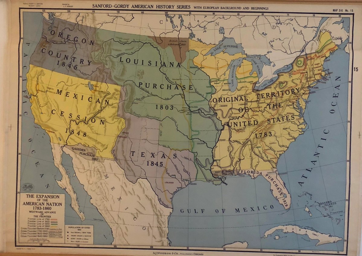
@scarlett_sA long read on how the United States expanded between 1783, 1860
Ver publicação original@scarlett_sA long read on how the United States expanded between 1783, 1860
Ver publicação originalFoto de @scarlett_s· Sep 24, 2026· United States
The image is a historical map of the United States. It depicts territorial expansion with different colored regions labeled with purchases and annexations like the Louisiana Purchase, Mexican Cession, and Texas 1845. The map has a vintage educational style. Notable details include the various dates associated with each territorial acquisition and the detailed labeling of geographical features and boundaries. ON-SCREEN TEXT: SANFORD-GORDY AMERICAN HISTORY SERIES WITH EUROPEAN BACKGROUND AND BEGINNINGS MAP S-G No. 15 THE EXPANSION OF THE AMERICAN NATION 1783-1860 WESTWARD ADVANCE THE FRONTIER Frontier Line of 1790 Frontier Line of 1820 Frontier Line of 1850 Frontier Line of 1860 Cities Founded Before 1790 Cities Founded 1790-1840 Cities Founded 1840-1860 POPULATION OF CITIES 1860 OVER 100,000 NEW YORK 50,0
 NBA YoungBoy Texas Gang Classification
 NBA YoungBoy federal investigation
 Ken Urker Gypsy Rose Blanchard fiancé
 2Louisiana state of emergency diesel
 Milo Yiannopoulos ICE detention
 Milo Yiannopoulos detained by ICE in Louisiana
 SpaceX Starbase Louisiana construction
 Louisiana pastor convicted of stealing $340K from churches
 2Daniel Cressy gene therapy sickle cell cure
 Daniel Cressy sickle cell cure CRISPR Louisiana
 2Daniel Cressy sickle cell cure Louisiana
 Paige youngest WWE Divas Champion Guinness World Record
 2Olivia Rodrigo LA pop-up events
 Oak Alley Plantation 300 Year Old Trees
 Oak Alley Plantation Oak Trees 🙂
 Oak Alley Plantation Oak Trees 🙂
@scarlett_sA long read on how the United States expanded between 1783, 1860
Ver publicação originalFoto de @scarlett_s· Sep 24, 2026· United States
The image is a historical map of the United States. It depicts territorial expansion with different colored regions labeled with purchases and annexations like the Louisiana Purchase, Mexican Cession, and Texas 1845. The map has a vintage educational style. Notable details include the various dates associated with each territorial acquisition and the detailed labeling of geographical features and boundaries. ON-SCREEN TEXT: SANFORD-GORDY AMERICAN HISTORY SERIES WITH EUROPEAN BACKGROUND AND BEGINNINGS MAP S-G No. 15 THE EXPANSION OF THE AMERICAN NATION 1783-1860 WESTWARD ADVANCE THE FRONTIER Frontier Line of 1790 Frontier Line of 1820 Frontier Line of 1850 Frontier Line of 1860 Cities Founded Before 1790 Cities Founded 1790-1840 Cities Founded 1840-1860 POPULATION OF CITIES 1860 OVER 100,000 NEW YORK 50,0
Ainda não há comentários. Seja o primeiro!
NBA YoungBoy Texas Gang ClassificationNBA YoungBoy federal investigationKen Urker Gypsy Rose Blanchard fiancé2Louisiana state of emergency dieselMilo Yiannopoulos ICE detentionMilo Yiannopoulos detained by ICE in LouisianaSpaceX Starbase Louisiana constructionLouisiana pastor convicted of stealing $340K from churches2Daniel Cressy gene therapy sickle cell cureDaniel Cressy sickle cell cure CRISPR Louisiana2Daniel Cressy sickle cell cure LouisianaPaige youngest WWE Divas Champion Guinness World Record2Olivia Rodrigo LA pop-up eventsOak Alley Plantation 300 Year Old TreesOak Alley Plantation Oak Trees 🙂Oak Alley Plantation Oak Trees 🙂
Ainda não há comentários. Seja o primeiro!