iFANN
    Buscar no iFANN...
    Entrar
    Início
    Notícias
    Vídeos
    Fotos
    GIFs
    Explorar
    Enquetes
    Prêmios
    iFAMOUS
    Wiki
    Anime
    Salas
    Notificações
    Mensagens
    Salvos
    Perfil
    WikiPrêmiosiFAMOUSRankingsSetoresRecompensas para criadoresRecompensas para usuáriosTermosPrivacidadeDiretrizes da comunidadeRemoção / DMCAAjudaDesenvolvedores

    © 2026 iFANN

    Início
    Buscar
    Mensagens
    Alertas
    Perfil
    Foto
    Jolyon
    Jolyon@jolyon3w
    💭News💭Politics
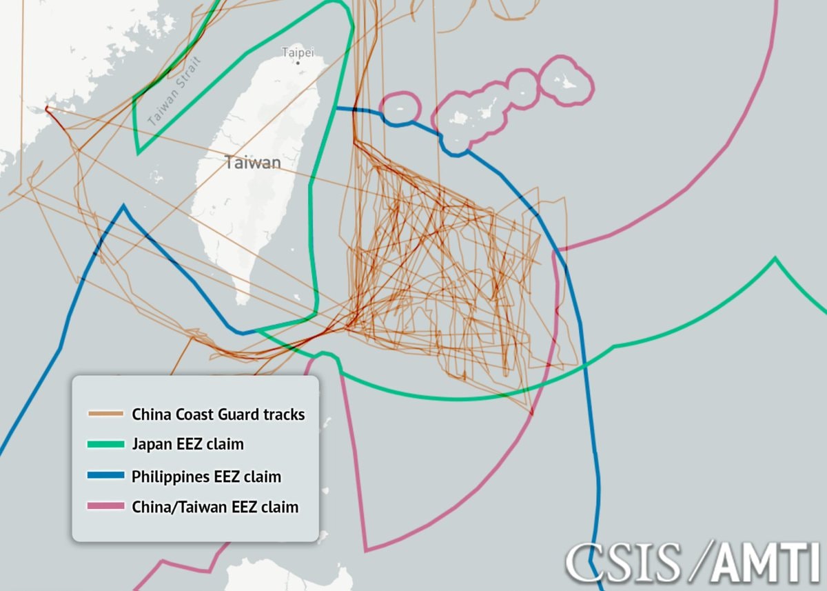
    China Coast Guard tracks east of Taiwan (photo 1 of 3)
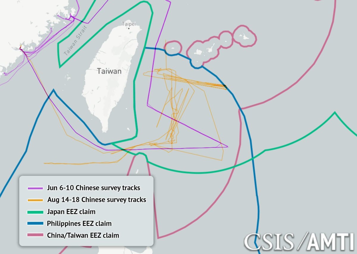
    China Coast Guard tracks east of Taiwan (photo 2 of 3)
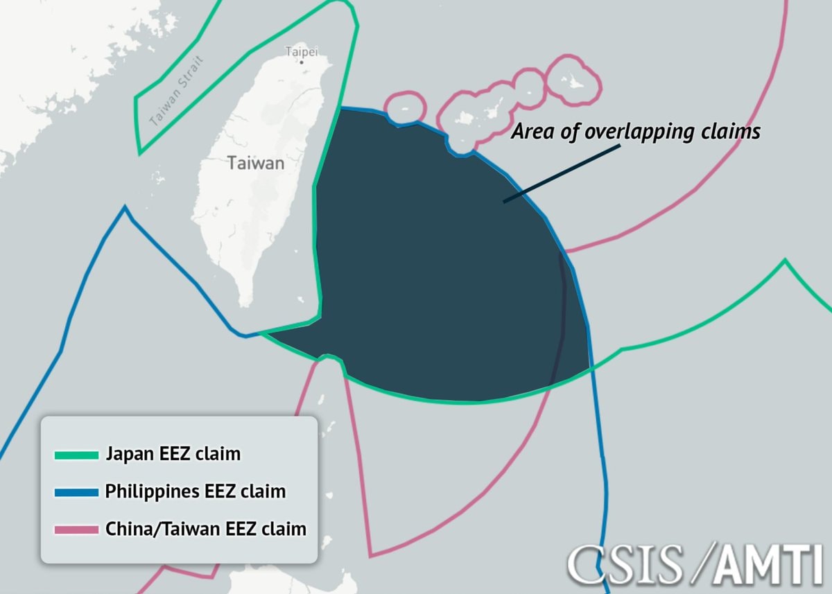
    China Coast Guard tracks east of Taiwan (photo 3 of 3)

    @jolyonChina's coast guard intercepted 198 commercial vessels east of Taiwan, demanding crew rosters and destination ports. This escalation followed Japan and the Philippines announcing boundary talks in May to resolve overlapping claims between the Ryukyus and the Batanes. Beijing declared those discussions null and void before deploying survey ships, 10,000-ton patrol boats, and coast guard hulls that have held station since June. Interrogating merchant traffic posing no threat to seabed resources exceeds enforcement rights under UNCLOS, even within a coastal state's own zone. Most surveying occurred within 50 miles of Taiwan, far from the actual boundary line. Since these talks typically span years, the source suggests this pattern mirrors a rehearsal for quarantining Taiwan. Visual data from CSIS/AMTI tracks these movements on a map showing EEZ claims across the region.

    Ver publicação original


    China Coast Guard tracks east of Taiwan

    Foto de @jolyon· Aug 22, 2026· Foto 1 de 3· News

    Sobre esta foto

    The image is a map showing maritime boundaries and ship tracks in the waters around Taiwan. It displays the Taiwan Strait, Taiwan itself, and surrounding EEZ claims from Japan, the Philippines, and China/Taiwan. Numerous orange lines, labeled "China Coast Guard tracks," crisscross the waters, particularly east of Taiwan. The overall style is informational and data-driven, with a watermark in the lower right corner reading "CSIS/AMTI."

    Ver todas as fotos de News

    ?

    Ainda não há comentários. Seja o primeiro!

    Mais fotos de News

    Ver todas as fotos de News
    $61 million crypto seizure from Iranian oil$61 million crypto seizure from Iranian oilanime character in Crunchyroll shirtanime character in Crunchyroll shirtNorth West reaction to Kai Cenat Gigi reunionNorth West reaction to Kai Cenat Gigi reunionMartha Stewart nudes decisionMartha Stewart nudes decisionDmitry Medvedev on AI honestyDmitry Medvedev on AI honestyCartrack customer data breach confirmedCartrack customer data breach confirmedUS Strategic Petroleum Reserve lowest since 19823US Strategic Petroleum Reserve lowest since 1982Ella Langley Tate McRae new photoElla Langley Tate McRae new photoLebanon displacement data September 93Lebanon displacement data September 9Countries ranked by average mood scoreCountries ranked by average mood scoreKojima Productions Xbox partnershipKojima Productions Xbox partnershipI'm single and searching 😔I'm single and searching 😔
    Foto
    Jolyon
    Jolyon@jolyon3w
    💭News💭Politics
    China Coast Guard tracks east of Taiwan (photo 1 of 3)
    China Coast Guard tracks east of Taiwan (photo 2 of 3)
    China Coast Guard tracks east of Taiwan (photo 3 of 3)

    @jolyonChina's coast guard intercepted 198 commercial vessels east of Taiwan, demanding crew rosters and destination ports. This escalation followed Japan and the Philippines announcing boundary talks in May to resolve overlapping claims between the Ryukyus and the Batanes. Beijing declared those discussions null and void before deploying survey ships, 10,000-ton patrol boats, and coast guard hulls that have held station since June. Interrogating merchant traffic posing no threat to seabed resources exceeds enforcement rights under UNCLOS, even within a coastal state's own zone. Most surveying occurred within 50 miles of Taiwan, far from the actual boundary line. Since these talks typically span years, the source suggests this pattern mirrors a rehearsal for quarantining Taiwan. Visual data from CSIS/AMTI tracks these movements on a map showing EEZ claims across the region.

    Ver publicação original

    China Coast Guard tracks east of Taiwan

    Foto de @jolyon· Aug 22, 2026· Foto 1 de 3· News

    Sobre esta foto

    The image is a map showing maritime boundaries and ship tracks in the waters around Taiwan. It displays the Taiwan Strait, Taiwan itself, and surrounding EEZ claims from Japan, the Philippines, and China/Taiwan. Numerous orange lines, labeled "China Coast Guard tracks," crisscross the waters, particularly east of Taiwan. The overall style is informational and data-driven, with a watermark in the lower right corner reading "CSIS/AMTI."

    Ver todas as fotos de News

    ?

    Ainda não há comentários. Seja o primeiro!

    Mais fotos de News

    Ver todas as fotos de News
    $61 million crypto seizure from Iranian oil$61 million crypto seizure from Iranian oilanime character in Crunchyroll shirtanime character in Crunchyroll shirtNorth West reaction to Kai Cenat Gigi reunionNorth West reaction to Kai Cenat Gigi reunionMartha Stewart nudes decisionMartha Stewart nudes decisionDmitry Medvedev on AI honestyDmitry Medvedev on AI honestyCartrack customer data breach confirmedCartrack customer data breach confirmedUS Strategic Petroleum Reserve lowest since 19823US Strategic Petroleum Reserve lowest since 1982Ella Langley Tate McRae new photoElla Langley Tate McRae new photoLebanon displacement data September 93Lebanon displacement data September 9Countries ranked by average mood scoreCountries ranked by average mood scoreKojima Productions Xbox partnershipKojima Productions Xbox partnershipI'm single and searching 😔I'm single and searching 😔